CRASAR · Texas A&M University · Florida State University
NSF AI Institute for Societal Decision-Making

CLARKE

Computer vision and Learning for Analysis of Roads and Key Edifices

Know which buildings and roads are damaged in minutes, on‑site.

Automated building and road damage assessment from small Uncrewed Aerial System (sUAS) imagery, built to give first responders fast, reliable situational awareness after disasters.

Proven in the field at Hurricanes Helene & Debby (2024). Given a finished orthomosaic, CLARKE assesses roughly 2,000 buildings in about 7 minutes and it's now part of FL‑UAS1's standard operating procedures.

125 Users Trained
63 Agencies Trained
2
Operational Deployments
(Hurricanes Helene & Debby)

How It Works

1

Fly

An sUAS crew flies the affected area and captures imagery using standard mapping flight patterns.

2

Process

Imagery is stitched into a georectified orthomosaic and aligned to building and road footprints.

3

Assess

The BDA and RDA models score damage per building and per road segment directly on-site.

4

Act

Responders get a structure-by-structure, road-by-road damage map in about 7 minutes per orthomosaic.

CLARKE's outputs are provided as GeoJSON and KML that drops straight into TAK, ArcGIS Online, and other common operating pictures.

The Models

Every assessment is reviewed by a trained operator before it reaches decision-makers. CLARKE is built to augment responder judgment not to replace it.

BDA — Building Damage Assessment

Classifies damage severity for individual building footprints from georectified sUAS orthomosaics, giving responders a structure-by-structure view of impact across an affected area.
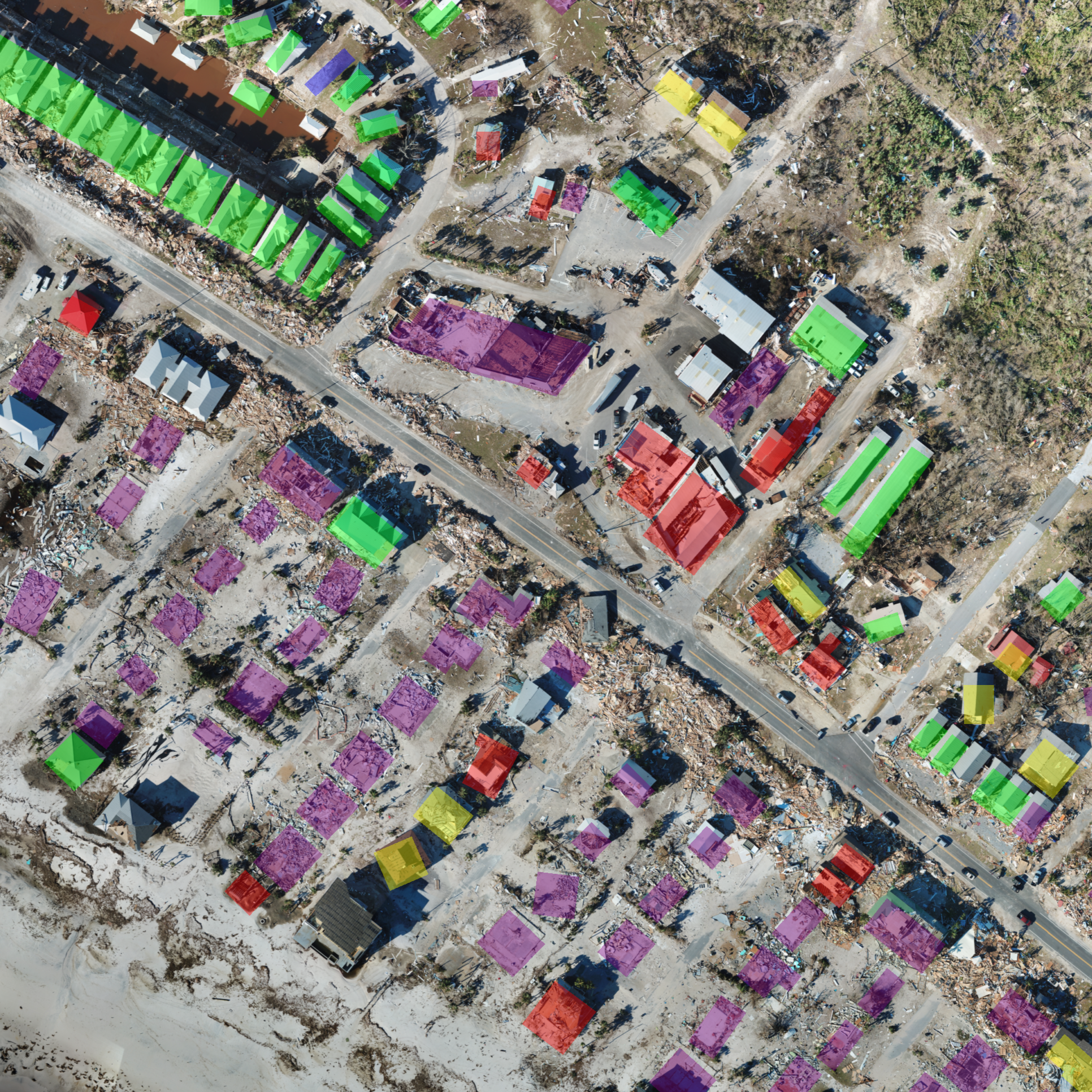
BDA Model output example
Sample Outputs
Spatial Data KML GeoJSON CSV
Documents Report Slides

RDA — Road Damage Assessment

Identifies and characterizes road network damage and obstructions from drone imagery, supporting rapid assessment of access and mobility routes for response and recovery operations.

RDA Model output example
Sample Outputs
Spatial Data KML GeoJSON
Documents Report Slides

The sample outputs show CLARKE's assessments on sUAS imagery of Mexico Beach, Florida from Hurricane Michael (2018). Hurricane Michael represents test imagery CLARKE never saw during training.

Built for the Field

CLARKE's models are designed to run entirely in the field, on hardware small enough to carry in with your team — no wireless transmission of imagery or data is required to generate an assessment. Data collected during a deployment is used only for model training and research with the permission of the responding agency. CLARKE is grant-funded by the National Science Foundation and provided free of charge to responding agencies with team oversight.

Built on CRASAR-U-DROIDs

CLARKE's models are trained and benchmarked on CRASAR-U-DROIDs, a large-scale benchmark dataset for building alignment and damage assessment in georectified sUAS imagery — 265 orthomosaics, 122,502 building views, and 21,716 building polygons spanning 10 federally declared disasters and 70.6 gigapixels of imagery.

Operational Track Record

CLARKE isn't a proof of concept, it has supported real disaster response and is now part of FL‑UAS1's standard operating procedures. Here's where it has been used in the field:

CLARKE is developed and maintained by CRASAR, the oldest institution devoted to promoting the use of ground, marine, and aerial unmanned systems for public safety. Since 2001, its trained volunteers have assisted incident command at over 30 disasters including building collapses, earthquakes, floods, hurricanes, marine mass casualty events, nuclear accidents, tsunamis, underground mine explosions, and volcanic eruptions across 5 countries.

In the Press

Team

CLARKE is built by a cross-disciplinary team of roboticists, emergency-management researchers, and engineers. We work hand in hand with the universities, institutes, and agencies below, whose support and field partnership make this work possible.

Research

Selected publications from the CLARKE / CRASAR team on disaster response and damage assessment: